Veiled Venus
October 8, 2014
While
visible markings were apparent on
Mars when viewed through better quality
telescopes,
Venus was always a mystery. The thick
atmosphere of Venus cloaked its surface features. It wasn't until the emergence of
radar imaging, first from
Earth, then later by
orbiting spacecraft, that the
topography of Venus was revealed.
Venus Unveiled
Venus should be the goddess of wardrobe malfunction.
The Roman goddess, Diana, who was the goddess of the hunt, was often described as being nuda genu; that is, bare at the knee. That's because she wore a short skirt that wouldn't impede her movements. Venus, however, as the goddess of love, was not adverse to going full monty.)
Before that time,
science fiction authors wrote about a hot and
humid Venus, somewhat like Earth in its
Carboniferous period. The
scientific justification for this came from no less than a
Nobel laureate. As
Svante Arrhenius, who was awarded the 1903
Nobel Prize in Chemistry, wrote in "The Destinies of the Stars,"
"A very great part of the surface of Venus is no doubt covered with swamps, corresponding to those on the Earth in which the coal deposits were formed, except that they are about 30 C (54° F.) warmer."[1]
That idea became untenable in 1922 when
astronomers showed that the
spectroscopic signatures of
water and
oxygen were absent in the atmosphere of Venus.[2]
Speculation then morphed Venus into a
dry,
desert planet. Further
research showed that the
atmosphere of Venus is quite a bit different from
Earth's. The atmosphere is mostly
carbon dioxide (96.5%) and
nitrogen (3.5%), with a considerable quantity of
sulfur dioxide (150 ppm). The surface pressure is 93
bar; that is, nearly a hundred times that of the Earth. The surface
temperature is about 450°C.
As they say,
a picture is worth a thousand words, and the
Soviet Venera 9 spacecraft landed on Venus in 1975 and survived long enough to
transmit back to Earth the first image of the surface of Venus (see figure). This was the first image returned from the surface of another planet.
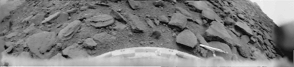
The Venera 9 image of the surface of Venus. The location of the lander was at 32° S, 291° E, and the image was taken with the Sun near zenith on October 22, 1975. (Processed Venera 9 image, used with the permission of Don P. Mitchell. Copyright 2003, Don P. Mitchell, all rights reserved.)
Since the atmosphere of Venus prevents
optical mapping of its surface features, there have been several spacecraft sent to Venus with
radar mapping capability. In 1978, the
Pioneer Venus Orbiter, also known as Pioneer 12, arrived at Venus for mapping with a 20
Watt S-band (1.757 GHz) radar capable of resolving 23 x 7
kilometer patches of the planet. This spacecraft provided useful data through 1992.
The Soviet
Venera 15 and
Venera 16 spacecraft reached Venus within a day of each other in 1983. These spacecraft were equipped with
synthetic aperture radar, and they imaged about 25% of the surface in eight months of operation. As
technology advanced, so did the radar mapping capability of spacecraft. 1989 saw the launch of the very successful
Magellan mission to Venus.
Magellan was unconventionally launched from a
Space Shuttle with an assist from an
Inertial Upper Stage booster. The spacecraft used
aerobraking (a technique
dramatically depicted in the
film,
2010: The Year We Make Contact) to
circularize its Venus orbit. The Magellan synthetic aperture radar produced a very complete mapping of Venus, as shown in the figure.
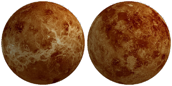
Full globe radar map of Venus by the Magellan spacecraft. The colors are not the colors of Venus; rather, they are a color representation of altitude. (Via Wikimedia Commons.)
Computer image processing has allowed some spectacular representations of some Venus surface features, such as
Maat Mons, the highest volcano and the second highest mountain, as shown in the figure. This mountain (mons) is named after
Maat, the Egyptian Goddess of truth and justice.
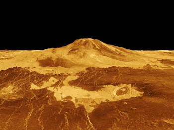
Maat Mons, the highest volcano and the second highest mountain on Venus, shown from processed radar data.
The vertical scale in this representation has been exaggerated by a factor of ten.
(Via Wikimedia Commons.)
Research on the atmosphere of Venus continues, and data from the
European Space Agency Venus Express may have explained mysterious holes found
decades ago in its
nightside ionosphere. Analysis by
NASA scientists at the
Goddard Space Flight Center reveals that the Sun's
magnetic field lines may be penetrating into the
crust of Venus, as the location of the holes indicates.[3-5] Says NASA scientist and research team leader,
Glyn Collinson,
"This work all started with a mystery from 1978... When Pioneer Venus Orbiter moved into orbit around Venus, it noticed something very, very weird – a hole in the planet's ionosphere. It was a region where the density just dropped out, and no one has seen another one of these things for 30 years."[3]
The
solar wind, when it reaches Venus, creates a
plasma and a
thin magnetosphere, much smaller than Earth's. The structure of this magnetosphere is apparently responsible for the creation of two long
cylinders of low density material on the side of the planet away from the Sun (see figure). Says Collinson, "The lines go right through down to the planet's surface and some ways into the planet."[3]
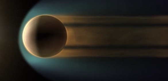
Trailing plasma holes in the solar wind behind Venus. (Still image from a YouTube video by NASA's Goddard Space Flight Center/G. Duberstein.)[4)]
References:
- Svante Arrhenius, "The Destinies of the Stars," Joens Elias Fries, Translator, G.P. Putnam's Sons, New York & London, 1918, pp. 251f.
- Chas E. St. John and Seth B. Nicholson, "The Physical Constituents of the Atmosphere of Venus," Phys. Rev., vol. 19 (April 1, 1922), pp. 444ff.
- Karen C. Fox, "NASA Research Helps Unravel Mysteries Of The Venusian Atmosphere," NASA Goddard Space Flight Center Press Release, September 11, 2014.
- The Mysterious Holes in the Atmosphere on Venus, NASA YouTube video, September 11, 2014. Available for download, here.
- ESA Venus Express website.
Permanent Link to this article
Linked Keywords: Martian canal; visible marking; Mars; telescope; Venus; atmosphere of Venus; radar imaging; Earth; orbit; orbiting; spacecraft; topography; Venus mythology; goddess; wardrobe malfunction; Roman mythology; Roman goddess; Diana mythology; hunting; hunt; nudity; bare; knee; skirt; love; full monty; art; Paris, France; Wikimedia Commons; science fiction; author; Venus in fiction; humidity; humid; Carboniferous; geologic time scale; period; science; scientific; Nobel laureate; Svante Arrhenius; Nobel Prize in Chemistry; swamp; coal; coal deposit; celsius; Fahrenheit; astronomer; spectroscopy; spectroscopic signature; water; oxygen; speculation; arid; dry; desert; research; atmosphere of Venus; atmosphere of Earth; carbon dioxide; nitrogen; sulfur dioxide; bar; temperature; a picture is worth a thousand words; Soviet Union; Soviet; Venera 9; transmitter; transmit; Venera 9; Sun; zenith; processed Venera 9 image; Don P. Mitchell; optics; optical; map; mapping; radar mapping; Pioneer Venus Orbiter; Watt; S-band; kilometer; Venera 15; Venera 16; synthetic aperture radar; technology; Magellan spacecraft; Space Shuttle; Inertial Upper Stage; booster; aerobraking; dramatic; film; 2010: The Year We Make Contact; circularize; altitude; Computer image processing; Maat Mons; Maat; volcano; mountain; European Space Agency; Venus Express; decade; nightside; ionosphere; NASA; scientist; Goddard Space Flight Center; magnetic field line; crust; Glyn Collinson; density; solar wind; plasma; magnetosphere; cylinder; YouTube video; The Destinies of the Stars.